

The go-to suite of solutions for a family of surveyors Three generations of Wisconsin surveyors choose Spectra Geospatial® for their…...

Cincinnati, Ohio, October 2021 – Spectra Geospatial and Precision Laser & Instrument (PLI), a Spectra Geospatial Authorized Distribution Partner, have…...

Le Tampon, La Réunion, (February 2021) – Piton de la Fournaise (Peak of the Furnace), one of the world’s most…...

Nantes, France (February 2021) – A Spectra Geospatial SP90m GNSS receiver provided the precise position and boat heading information for…...

Athens, Greece (January 2021) – A two-person Astrolabe Engineering survey team using a single SP60 GNSS receiver recently completed the…...

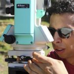
Worcester, UK (January 2021) — The Survey School has received three Spectra Geospatial SP85 GNSS receivers with Ranger 7 data…...

Nairobi, Kenya (October 6th, 2020) – The Mau Forest Complex in the Rift Valley in Kenya is the largest indigenous…...

Nantes, France (September 14th, 2020) — The Spectra Geospatial SP90m GNSS receiver has been selected by the racing yacht Maître…...
Ambridge, PA; March 2020, Spectra Geospatial and Precision Laser & Instrument (PLI), a Spectra Geospatial dealer in Western Pennsylvania, West…...

Casablanca, Morrocco; February 2020, Vibrations during the construction of a new 1,890-meter tunnel adjacent to Casablanca’s Old Medina, the 250-year-old…...

Trimble technology produces cost saving and high accuracy results using Spectra Geospatial SP60 GNSS in combination with Trimble CenterPoint RTX…...

Yorkshire, UK, October 2019 – Verified photomontage is an important planning tool to envision how proposed surrounding development plans would…...

Huizhou City, China (April 2018)— FOCUS 35 robotic total stations are hard at work helping build the world’s largest expressway…...

Nouakchott, Mauritania, (January 2018) – The SP60 GNSS receiver has been selected to perform survey work for construction of a…...

Paphos, Cypress, (August 2017) – Students from AGH University of Science and Technology in Krakow, Poland recently combined archaeology and…...

Athens, — On the island of Euboea, Greece’s second largest island lying just off the coast of Athens, surveys for…...

Preston, Lancashire, UK (November 28, 2016). To increase interest and involvement of people in protecting and improving the Ribble River,…...

Tarn, France (May 23rd, 2016) — At the Rassisse dam on the Dadou River in southwest France, a Spectra Precision…...

Leicestershire, March 10, 2016 – When a topographic survey for the main runway of the East Midlands International Airport was…...

Krakow, March 9, 2016. The agency responsible for the supervision and control of European Union agricultural subsidies in Poland, the…...

Nay Pyi Taw, Myanmar (September 25, 2015) — The Agricultural Land Management and Statistic Department (ALMS) in Myanmar recently concluded…...

Nairobi (June 8th, 2015) — The Kenya Department of Surveys has acquired eight FOCUS 30 total stations and an additional…...

São Paulo, March 17, 2015 – Saneamento Basico do Estado de São Paulo (SABESP), a Brazilian water and sewage collection…...

Westminster, CO 17th March, 2015 — When the beach authority of the Department of Environmental Protection of a major southern…...

During this past Intergeo 2014 in Berlin, we had the pleasure to have Lisa Makelberge selected as the winner of…...

Kuching, Sarawak, Malaysia, (December, 11th,2014) — When the Land Survey Department of Sarawak wanted to upgrade its cadastral survey capability,…...

Saskatchewan Bridges in Better Shape with Aid of FOCUS 30 Robotic Total Stations Saskatchewan, Canada, (November 21st, 2014) -Across the…...

Ankara, November 21st, 2014 – The Geomatics Group, a leading Spectra Precision distributor and GIS software developer in Turkey, is…...

Budapest, (November 12th, 2014) – Bombariado, a company expert in explosive ordnance detection, clearance and disposal, has upgraded its detection…...

Harfsen, Netherlands (November 6th, 2014)– InfraRadar, an advanced mobile ground penetrating radar infrastructure locator, developed and manufactured here by GT…...

ProMark 800 Aids Demining Operations in Bosnia-Herzegovina Br?ko, Bosnia and Herzegovina (October 16, 2014) – Bosnia and Herzegovina is burdened…...

Melbourne, Australia (September 8, 2014) – The benefits of the Spectra Precision SP80 GNSS receiver with its multi-constellation capabilities has…...

Riga, Latvia November 25-2013- The Second Annual Latvian Esri GIS User Conference, held October 15-16 at the Citadele Conference Hall…...

Trimtec and ProMark 700 Make a Big Hit at MaskinExpo It was the best year ever for Trimtec, Spectra Precision’s…...

Athens, May 23, 2013 – The Athenian port of Piraeus, a major commercial and Europe’s largest passenger port, will soon…...

Economy and Precision for Survey and Cadaster Academic Studies Corum, Turkey – January, 2013 – The Hittite University School of…...

Warsaw – November 7th, 2012 – One of the world’s most successful military training aircraft, the PZL-130 TC Orlik, manufactured…...

Bamako, Mali – June 15, 2012 – In the heart of landlocked Mali, the Atlantic Ocean 800 miles to the…...
Olsztyn, Poland, April, 24, 2012 – Okr?gowe Przedsi?biorstwo Geodezyjno-Kartograficzne (OPGK) a major survey firm working on road survey contracts across…...

Riga, Latvia, June 11th, 2012 – The Latvian State Forest Service (SFS) recently evaluated four leading brands of GNSS handheld…...

Ermont, France, 2012 — GNSS speed and accuracy are achieving new levels of performance with the ProMark 500. In a…...

Beneath the surface of this tropical paradise in the city of Townsville on Australia’s Sunshine Coast lies a still hidden…...

Confirming the accuracy of as-built plans for recently buried fiber optic, gas and electric lines has become much simpler and…...

Following last year’s devastating earthquake, Haiti’s reconstruction effort has an urgent and growing need for precise geospatial information. To help…...

Lloyd Baker performed his first field surveys in Cokeville, Wyoming in 1937. More recently, in the week of his 100th…...

In late autumn 2009, 200 kilometers north of Quebec City, a survey crew from Genivar, one of Canada’s largest engineering…...

Kicking off National Surveyor’s Week in the U.S. this spring was an opening day “Surveying USA” event sponsored by the…...

The Hungarian Chamber of Agriculture (HCA), a public national agricultural informational and advisory service assisting Hungarian agricultural producers, has recommended…...

As part of a major upgrade and renewal of the Swiss Metrological Network of weather stations, the Swiss Federal Office…...

Greek cartographers use MobileMapper 100 to produce first totally field-researched, information-rich maps for cyclists, hikers, climbers, canyoners and sailors Terrain,…...

Interview teams assisted by Team Epi-Aid, an award-winning volunteer group at the University of North Carolina Gillings School of Global…...

Forty-nine Ashtech MobileMapper 6 GPS/GIS field terminals have been purchased by two key Republic of Kosovo agencies, the Kosovo Property…...

The Ashtech ProFlex 500 receiver has been selected to provide GNSS position data to the recently introduced FieldSens underwater utility…...

As Bosnia develops into a mature, representative democracy, the role of local governments and municipalities grows in importance. The Governance…...

Five Ashtech ProFlex 500 GNSS receivers are helping guide the operations of the self-propelled jack-up vessel Bard Wind Lift I,…...

When T-Com, the fixed line business division of Slovak Telkom Group, recently undertook to map its underground fiber optic communication…...

Along the border between extreme northern Maine and western New Brunswick, Canada, two surveyors, one Canadian and one American, have…...

Yunnan Power Grid, a major electric power grid management corporation serving five provinces in southern China, has ordered 160 Ashtech…...

Teck Coal, a major Canadian coal producer, has recently upgraded the computer navigation system on its fleet of 30 Caterpillar…...

A year after replacing its measuring-tapes and survey compasses with 124 MobileMapper CX handheld GPS/GIS data collectors, the Latvian State…...
- Spectra Geospatial Partners
- Nikon Partners
PARTNERS