OVERVIEW
It can be challenging or even impossible for surveyors to work with GNSS equipment in cities where high buildings create urban canyons, or in forests with dense tree canopy. Nevertheless these are places where surveyors have to work more and more often, and they would like to use their GNSS equipment in these environments just as they do in other, less difficult, conditions.
Spectra Geospatial responded to this need by developing the Z-Blade positioning technology which is currently available in a range of GNSS receivers. This unique technology carefully optimizes the combining and data processing of signals from the different GNSS systems. The resulting “GNSS-centric” approach brings independence from the GPS system and allows any combination of GNSS satellite signals to be used together. The Z-Blade GNSS-centric technology increases RTK position availability in obstructed areas where satellite visibility is limited, which in turn enables surveyors to work more productively and efficiently.

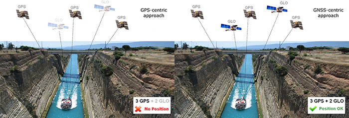
The underlying premise of the Z-Blade GNSS-centric technology is relatively simple. It assumes that each satellite available in the sky is equal to any other, and that satellite signals can be used interchangeably for position calculations. In this approach, there is no underlying reliance on GPS signals, and indeed RTK positioning is possible with no GPS satellites whatsoever. This approach increases the potential satellite availability significantly, and even in areas where many satellites are not visible due to obstacles, there is a high likelihood of sufficient remaining GNSS satellites to calculate a position and fix RTK.
The difference between these two pictures above is quite clear. The first presents the standard GPS-centric approach, which is used by most of the GNSS receivers available on the market today. If there are insufficient visible GPS satellites (e.g. only three GPS satellites) then no position can be calculated, even if several other GNSS (e.g. GLONASS) satellites are visible. The second picture presents the Z-Blade GNSS-centric approach. In this approach all available satellites are considered as equal to each other. There is no requirement to have a minimal number of GPS satellites; provided the total number of all available satellites is sufficient, RTK positioning is possible.
The Z-Blade GNSS-centric technology brings a number of important advantages to land surveyors.
- Position computation in harsh, obstructed environments where satellite visibility is poor
- Position computation even in the presence of GPS L1/L2 in-band jamming
- GLONASS-only mode, Beidou-only or Galileo-only modes for specific applications
- Fast and robust RTK fixes even on long-range baselines including VRS, MAC and FKP networks
- Optimal operation with 3rd party base stations
Z-Blade products help to keep surveyors working in challenging environments, and minimize the locations where it’s necessary to employ alternative surveying tools (for example, optical instruments). This unique technology enables surveyors to increase their accuracy, efficiency and productivity, thus maximizing the value of their GNSS equipment investment. As of today, Z-Blade technology is embedded in the following Spectra Geospatial products: SP80, SP60, SP90m.


 English
 Deutsch (German)
 Français (French)
 Português (Portuguese (Brazil))
 Español (Spanish)
 简体中文 (Chinese (Simplified))
